


balade du roux

raab
User
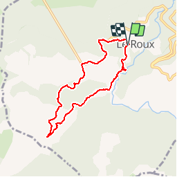

Length
7.2 km

Max alt
1008 m

Uphill gradient
301 m
Km-Effort
11.3 km

Min alt
758 m

Downhill gradient
303 m
Boucle
Yes
Creation date :
2018-07-30 16:23:35.221
Updated on :
2018-07-30 16:23:35.256
2h43
Difficulty : Easy

FREE GPS app for hiking
 SityTrail
IGN / Geographical institutes
SityTrail Plus
The world is yours!
About
Trail Walking of 7.2 km to be discovered at Auvergne-Rhône-Alpes, Ardèche, Le Roux. This trail is proposed by raab.
Positioning
Country:
France
Region :
Auvergne-Rhône-Alpes
Department/Province :
Ardèche
Municipality :
Le Roux
Location:
Unknown
Start:(Dec)
Start:(UTM)
590750 ; 4952879 (31T) N.
Comments